Note: JMeiser, who I'm pretty sure is the original developer of the Trans-WI route and race organizer for that event contacted me via the bikepacking.net forums, asking me for some comments on the route. I thought my notes could be useful for other folks who might try to ride this route, so I have copied them them below for people to search out. You can follow along and see the route by folllowing this link. Here is what I had to say:
I appreciate the opportunity to comment. I think the route has a lot of potential, it was a great trip and I got to see a lot of different parts of WI. In fact, you should consider contacting Adventure Cycling or WORBA about making this an "official" bike route across the state.
Overall I think there may be a difference between what a tourist wants out of a route and what makes a good race route. For example, a tourist is going to want to go through or near a town or park at regular intervals so they can resupply or stay for the night. And while with a race course you may want to make a route as challenging as possible, for touring something scenic and interesting is preferred, often following the shortest line of least resistance between points (points being good sections of trail/road or scenic wild areas or towns in this case).
For example, the section of the route between the WI River and Viroqua seems to zig-zag around and go up and down from valley to ridge and back again to an excessive degree. Is there a reason the route goes almost all the way back to the Miss. River? Is that trail in Slide Hollow park worth going over that way? I actually developed a "Kickapoo Valley Cut-Off" to shorten this section of the route and give me an opportunity to see the Kickapoo Valley region. In the end we decided we needed to stay indoors that night, so we didn't use the route since the nearest town that had a hotel was Viraqua. But after about 3 hours of only getting 30ish miles (on pavement!) going up and down those hills, we bailed off of the route south of Mt. Sterling and took Hwy 27 along the ridge top into Viraqua and made much better time doing it. Not as scenic, but traffic wasn't bad at all.
The first "trail" I hit on the route was west of Ft. McCoy, between Camp Ave and Anchor Ave. The gate there at Camp Ave is a little intimidating as there is no indication its public land. The first part of this bit of trail is overgrown, but passable. However, there is a point where the route splits off to the right, and heads onto an abandoned trail that was completely overgrown. I kept going on the same trail which angled off NW and dumped me out on Birch Rd, an old 2-track lane. I think this is a more reasonable route up to Anchor Avenue.
Immediately north of I-94, the sand road are ridiculously difficult and the deer flies are maddening. I appreciate having some challenge like this in the route, but at some point enough is enough. I bailed out and took Brockway Rd north, and I think this is really the only reasonable option, because these pure sand roads aren't going to be rideable really for anyone save perhaps a rider on a Pugsley, and they wander around for miles. I took Brockway to Hwy 54 and that back to the route.
The route goes RIGHT PAST Levis Trow, but not on the trails THROUGH it! Maybe you were trying to avoid people having to pay a trail pass fee, but this seems like a huge missed opportunity. It looks like you can pick up a trail right from the north end of Bachelor's Ave @ Hwy 95, and ride mostly singletrack around the south and east side of the mounds and across Goreman Ave to meet with the Trans-WI route again. Unfortunately the trails/roads were saturated to flooded as I went through here and I wasn't able to do this.
Near the north end of Bald Peak Ave where it meets Co Hwy I (near "Tioga" about 20 miles south of Thorp), the route cuts off of Balk Peak Ave westward on some ATV trails. Though the ~1 mile long stretch that goes SW is open, the section you turn right on there to head NW is no longer an open trail. It would be best to run the route up to Co Hwy I and then west back over to those ATV trails. However I can't speak to the condition of those trails over there since I was feeling sick that day and just took Co Hwy M straight north into Thorp.
NW of Thorp, at "Maplehurst", the intersection of CoHwy A and CoHwy T, the route sends us off onto Wildlife Road, then north on a small track up to Burma Dr. I read some trip reports from the 2010 race stating that this was private land and you had to ask permission to ride it, so I just took CoHwy T up to Burma Dr. When on Burma Dr. I tried to see where this track met the road and saw no road or trail of any kind. So I suggest just skipping this section of "trail".
North of Perkinstown the route needs a little work. It sends you west on CoHwy M on what seems to me to be a pointless (though scenic) loop on Forest Roads 574 and 572. Probably better to just take CoHwy M north to Forest Road 112. Then there is the whole bit where there is no bridge over the Yellow River on the route. I took FR112 north, then east on Homstead Rd, then north on Yellow River Road to go around this.
Then there is the stretch of "trail' or "road" north of CoHwy D (aka North St on google maps) that is COMPLETELY IMPASSABLE. It is completely overgrown (in areas bushwhacking through the woods was significantly easier then trying to follow the trail itself), then dumps down into a wetland, which is where I stopped, and then god only knows how wide that creek is. It was flooded even 50 yards away from the creek so there was no way I was going to go further. It would be better to just take Hwy D east to Hwy N, then take that north back to where it meets your route. This to me was the single biggest problem with the route.
North of Hayward I wondered if it was necessary for the route to sweep so far east to the west side of Lake Namekagon. I was feeling pretty sick that day and had some equipment issues as well, so I bailed out to US63 north of Seeley and took that north to Drummond. So I missed the whole stretch. Maybe you've got some good trail in there, but it seems like there are dirt roads that run just west of Cable that could be used instead that would run you closer to town for resupplying, also avoiding the temptation to short-cut the route.
The last 60ish miles of the route I thought were superb. But people should we be warned that there are no services at all. However, there is a bit there between Star Route Rd and Hwy13 where I suspect if the roads were wet it would be impassible. It was pretty dense clay, when I went through there were deep petrified truck tracks. Seems like the kind of soil that would have you dragging a bike if it were wet. Just something to note.
I hope you can tweak the route and get it some more attention. it was a great ride!
Wednesday, August 10, 2011
Wednesday, August 3, 2011
Gear Review: The Electronics

I will be the first to admit that I brought way too many electronics on this trip. You can see in this photo the Garmin Oregon 450 GPS unit, my iPhone 3GS, my Planet Bike Protoge 9.0 cyclocomputer, and in the bar-mounted bag on the right was my new Panasonic Lumix TS3 waterproof camera. Makes for a bit of bar clutter. In addition to this mess, I also carried around an Apple Bluetooth Keyboard, a Princeton Tec EOS headlamp, a New Trent external battery pack for the iPhone, back-up batteries for the camera, 6 rechargeable AA's for the GPS unit, a battery charger for the AA batteries, and 3 AAA Lithium-Ion back up batteries for the headlamp.
In theory the iPhone should be able to replace both the camera and the GPS unit, and meanwhile redue a lot of the spare battery clutter to boot. But as it turns out the iPhone is good at a lot of things, but not good enough at anything to be the sole unit I would rely upon. The camera quality on the 3GS sucks, and I'm not too optimistic that the iPhone 5 will be much better in this department unless they replace the epoxy bubble they use for a lens now with some optical quality glass. Also, there's not much controling the image you're getting out of the iPhone, I'd like to be able to control the shutter speed, ISO, manual focus (for macro shots) and most critically have an adjustable exposure compensation.
On the other hand, the Panasonic Lumix TS3 was an excellent little camera, a huge improvement over our old P&S camera. The controls are all easy to get to and adjust (not hard to access, stupid modes for fireworks, and candlelight, and firelight and starlight) its GPS enabled for geo-tagging my photos (important when photographing rare plants), waterproof and "shockproof". In fact, I dropped it onto asphalt while rolling along at 15mph, and after re-seating the SD card it works just fine. My only complaint is that its way to easy to get a finger, and thus a fingerprint on the lens and that its pretty expensive at over $300.
One more camera related review: the Eye-Fi Moble X2 SD card I used took a lot of work to set up properly, but once it was set up, I could wirelessly send photos from the camera to the iPhone ANYWHERE, no Wi-Fi network required. This along with the wireless keyboard meant that I could upload photos, type up, and post to my blog as long as I had the faintest cellular signal... or i could just compose the whole thing and post it once I rolled into a town where I got a phone signal. Brilliant.
As for that Apple Bluetooth Keyboard, it worked well and was relatively compact, and was waterproof as long as I kept it in a large zip-lock bag. However its pretty heavy being made out of a big hunk of aluminum. I was hoping to have the Jorno folding keyboard for this trip... to bad they're running a full year behind when they said they were going to release it... I preordered mine back last December and won't see it until next spring!
But the really crippling aspect of the iPhone that makes it useless for navigating and general use is the pathetic, abysmal, embarrassing battery life. I have to turn on every battery saving setting I can find, and then keep it in Airplane Mode most of the time, and it still runs out of batteries about 2/3rds of the way through each day while on tour. Then there is the hassle of turning Airplane Mode off, the switching to the app you want to use, waiting for the GPS to connect, figure out where you are and where you are going, then quit the app, so you can go back to setting and put it back in Airplane Mode before shutting it off.
This made the New Trent IMP880 8900mAh External Battery Pack, a necessary and trip-saving accessory. It charges from the wall, holds about 5 iPhone charges worth of battery power that you can dish out whenever you need it. There are other models and brands with different battery capacities for different folks, but this one I think is well suited to my needs. It worked flawlessly, really an accessory that every iPhone owner needs (at least until Apple gets their act together).
Apple needs to triple or quadruple the battery life on these phones. The battery inside the iPhone has less juice than a single AAA battery! I think they could increase the battery power this much by making it about 1/8th" thicker. I don't know why Steve Jobs is so obsessed with making the iPhone thinner, I have never heard anyone complain about their phone being too thick. Meanwhile, I have problems with the battery running down in daily use, not just on tour, and that's just pathetic. Apple also needs to develop a setting/mode to allow us to turn off all-cellular transmission/reception while leaving the GPS function on. Kind of like Airplane Mode + GPS. This, I would imagine would be easy to do, and it would save people like myself who both work and play out of the cell network a lot of battery power, since when the phone is "searching..." it takes a lot of extra juice.
All of this is a shame because the GPS software for the iPhone is pretty good (or at least maturing into something pretty good) and the GPS chip itself is about as accurate as any consumer-grade GPS device. I tested out both Motion-X GPS and Gaia GPS on this trip. Both apps allow you to download maps ahead of time so you don't have to rely on cellular coverage to see where you are going. In both you can upload GPS waypoints and tracks, so you can see your route. Motion-X is a bit more advanced in this department as you can manage these files through iTunes, but with Gaia, you have to email a GPX file to a special email address as an attachment, which works, but is clunky. Both apps have problems with tracks disappearing so you have to re-load them, but Gaia seems worse for this. Of course, the best solution for this would be if either app developed a desktop companion for their software to allow you to manage layers, maps, waypoints and tracks, but I'm not going to hold my breath for this.
Gaia has the huge advantage of being able to download actual USGS Topo maps. I found that these coupled with OpenStreet Maps was all I needed for navigation. However, the topo maps were hard to read with my iPhone 3GS, I'm hoping they work better with the RetinaDisplay on the iPhone 4. Gaia also has a lot of clutter on their maps screen, and while you can minimize it to some degree, I don't see why I need even a little tab to see the exact longitude and latitude coordinates of my location. I can't imagine this information ever having any practical use. It'd be nice to have the option to eliminate these entirely from the screen.
I have been using Motion-X GPS for a while, and it works OK, but its interface is too complicated and cluttered, its a bit buggy still. Also, though I spent HOURS downloading maps to this app before I left on my trip, some of them mysteriously disappeared, so I couldn't rely on Motion-X GPS to help me with navigation when I was out on the trail. Very frustrating. Overall, I Think if they could work out some bugs, streamline and simplify a bit and get the topo maps on there, this would be a solid App. But for now at least, despite its faults Gaia GPS is my choice for iPhone-based navigation.
Both of these apps have a lot of potential, but are unfortunately held back by the iPhone hardware. I think the outdoor enthusiasts best hope is if a case manufacture would come forward with a case that was not only a shock/water resistant case, but also had an extra battery pack built in. Right now you can buy one or the other, not both. Also, it would be good if someone came up with a decent handlebar mount for the iPhone, the Topeak iPhone Drybag I used worked, but you have to take it out of the bag to get a decent photo, and there's really no shock protection if you drop it. But their clip system worked great, and its the way I will be carrying around my iPhone on my bike for commuting and recreational rides back home.
The Garmin Oregon 450 is a decent GPS unit, and since this the first time I have used a GPS for navigation (I've used Trimble units for data gathering for scientific field work) I don't have a lot to compare it to. It works great when you're on the bike and need to know where to turn next. And it runs for a full day, and then some using NiMH rechargeable batteries. This made it my go-to navigation device. However, it has several faults. The user interface was clunky. And what really drove me crazy was that the topographic lines were in dark brown while the roads were in light grey, so it made it really hard to see where the roads were going in any area with rolling hills! I had to turn the topographic map off in the end and rely on a regular street map, which is not optimal. I should be able to adjust the apperance of the topo lines and the roads to meet my needs. Also, to switch between the "direction of travel is up" mode when navigating to the "north is up" mode when I just want to look at the route overall, you had to exit the map, open up the settings, etc. This took 8 taps of my finger to get there, really this should be something you should be able to do by one click to the compass in the upper left hand corner.
The small, low-resolution screen makes it very difficult to use if you are trying to look at the "map" and decide on a new route. The iPhone apps did this job a lot better, since you could easily zoom in and out and see a clear map of your surroundings. Or you could try a good, old-fashioned paper map. But either way, I would never take this GPS unit into the wild alone as my only navigation device. In this day and age with smart phone and other devices so prevalent, I think we expect more out of our hand-held devices. I think Garmin is in big trouble with their stand-along units. They are going to need to improve their screen quality, improve the quality of maps that they offer and provide a better user experience or they are going to be left in the dust by the GPS apps on smartphones. It is nice that Garmin provides a desktop companion for their units, called Garmin Basecamp, but it is really clunky software with 5 actual applications you have to download. Basically it works, but the user interface is crap and its buggy.
All I have to say about the Planet Bike Protoge 9.0 is that it works well, and that it displays the temperature as well as all of the standard bike computer info. Like a bank clock, it estimates a bit high in full sunlight, but seems pretty accurate in the shade, or when shaded by the shadow of my body. Also, somehow if you put your iPhone right next to it and start playing MP3's it will reset the Protoge... that's some serious electromagnetic interference, so beware of that.
All in all, if the iPhone could do what its supposed to do, I could have cut probably 2 pounds of electronic gear from my kit. Another solution I am considering is a generator hub hooked up to charge the iPhone while I ride. It would add a little bit of rolling resistance, but in return I would have all of the utility I need and a lot less electronic clutter!
Tuesday, August 2, 2011
Trans-WI: Wildlife in Bathrooms
The first two days of the trip I found surprising wildlife in the bathrooms I visited. Not worth noting alone, I thought they'd make a fun blog post together.
First, there was this spider in the stall in the men's bathroom at Yellowstone Lake State Park. It was easily the largest spider I had ever seen north of the Mason-Dixon line. The spread of its legs was about that of the palm of my hand! It didn't seem to mind my coming and going, and it was even kind enough to not jump on my face when I took this close-up photo of it:

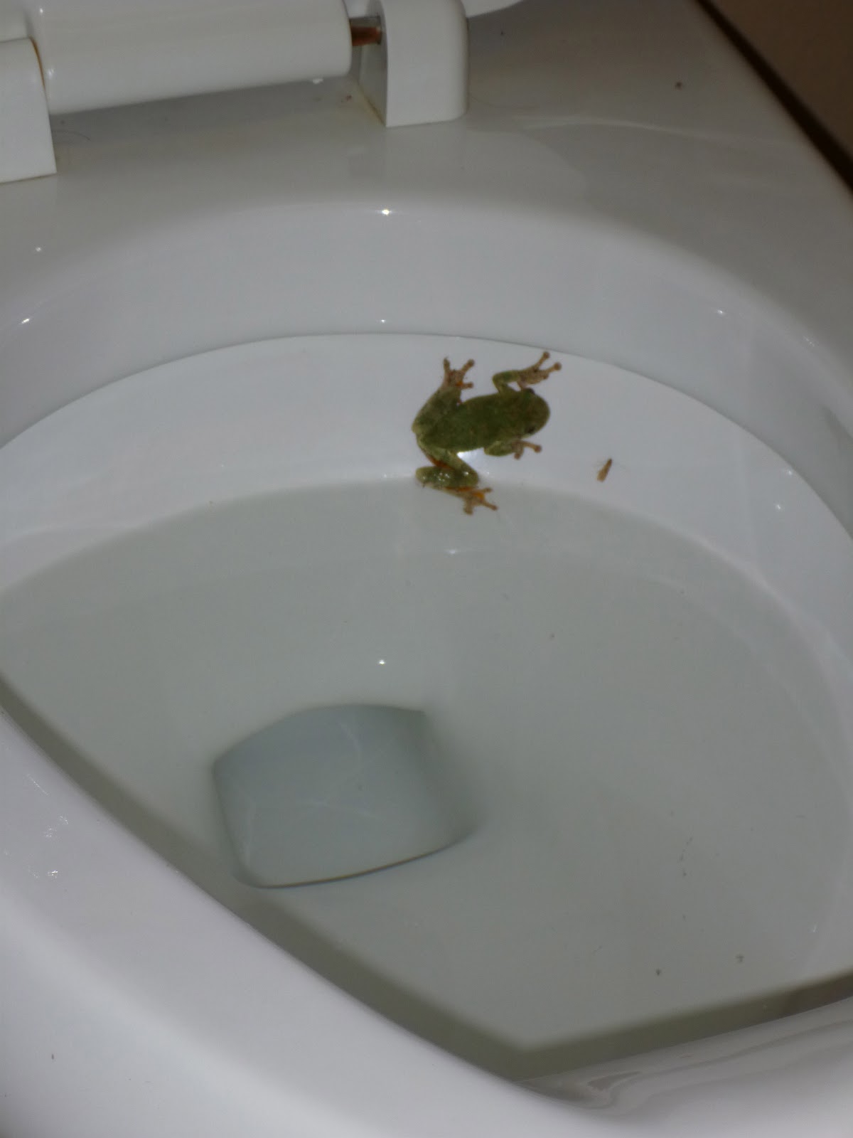
The next night we stayed at Nelson Dewey State Park. That night we rode out a storm in our tent. In the morning, in the seemingly sealed, clean bathroom with modern pluming, I found a treefrog in the toilet:


I shewed him out of the toilet, scooped him up, then took him outside to the nearest tree. Then of course, I washed my hands.
The last wildlife in the bathroom incident took place days later. I had just ridden through the grassy, overgrown trails in the "Kimberly-Clark Wildlife Area" and part of the reason that bit of trail was so rough was that I had to poop the whole time. I found a vacation cabin with an outhouse in back, so I decided I would make use of it. Since the house had modern plumbing, it seemed the outhouse wasn't used much. I began to "drop my load" and heard a high-pitched squeak in protest. As soon as I was able to, I jumpped up off of the seat! It was the screech of a bat, who had apparently decided that the inside of a pit toilet was a good roost! I still had to wipe though, they didn't like that either. I got out of there as quickly as I could, I didn't feel like getting rabies from getting bit on the butt by a bat in an out-house!
The rest of the wildlife I encountered on the trip were outside, where they belong.
First, there was this spider in the stall in the men's bathroom at Yellowstone Lake State Park. It was easily the largest spider I had ever seen north of the Mason-Dixon line. The spread of its legs was about that of the palm of my hand! It didn't seem to mind my coming and going, and it was even kind enough to not jump on my face when I took this close-up photo of it:

The next night we stayed at Nelson Dewey State Park. That night we rode out a storm in our tent. In the morning, in the seemingly sealed, clean bathroom with modern pluming, I found a treefrog in the toilet:

I shewed him out of the toilet, scooped him up, then took him outside to the nearest tree. Then of course, I washed my hands.
The last wildlife in the bathroom incident took place days later. I had just ridden through the grassy, overgrown trails in the "Kimberly-Clark Wildlife Area" and part of the reason that bit of trail was so rough was that I had to poop the whole time. I found a vacation cabin with an outhouse in back, so I decided I would make use of it. Since the house had modern plumbing, it seemed the outhouse wasn't used much. I began to "drop my load" and heard a high-pitched squeak in protest. As soon as I was able to, I jumpped up off of the seat! It was the screech of a bat, who had apparently decided that the inside of a pit toilet was a good roost! I still had to wipe though, they didn't like that either. I got out of there as quickly as I could, I didn't feel like getting rabies from getting bit on the butt by a bat in an out-house!
The rest of the wildlife I encountered on the trip were outside, where they belong.
Trans-WI: Epiloge
I went to bed Friday night feeling great. I was sure I was going to continue riding on across the UP of Michigan. As I started riding Saturday morning my attitude changed. My butt felt like there was sand in my bike shorts, and I was tired and sluggish. The UP route was about 80% state and US highways, and 485 miles long. Doing that in 4 days sounded like a pretty miserable long, painful grind at that point.
I continued to ride on towards Ashland, thought the remarkably small but obnoxiously touristy town of Bayfield.
 Obligatory photo of Bayfield with boats and water and rustic (rusting) things.
I rode on further and storms started firing up. I was able to find my way to a large porch before the rain started coming down too hard, and waited it out for over 30 minutes. Looking at the radar, it seemed it could rain more that day, and the forecast was calling for a wet week.
My thumb was still bothering me due to constant use, I was worried that my Random Fatigue Syndrome would return (indeed it was bothering me slightly at that time) and well there were half-a-dozen other little niggles. The ride ahead of me just didn't seem like it would be as much fun as the ride I had just done. Carol was driving up to meet me in Ashland to resupply me with some gear, and I knew she really wanted me to join her and drive to Traverse City with her.
So I relented. I gave her a call and told her to pick me up a few miles north of Ashland. I had ridden about 30 miles that day. We did a little auto-tour of the UP, checking out the Porcupine mountains, driving first along the Lake Superior coast, then through the interior of the peninsula, and finally along the Lake Michigan coast. By the following afternoon we were able to meet up with Valerie, her boyfriend Tony and his sister+cousin+cousin's boyfriend, and my father-in-law Jim gave everyone a tour of Chateau Chantal winery. So it worked out pretty well.
So here I sit on Old Mission Peninsula relaxing this week. I got my MTB working (I had removed the rear brake cable after a wet race 2 weeks ago and never reinstalled it) and did a short ride yesterday at the VASA Singletrack, but my thumb still bothered me so I cut it short. I have some more rides and hikes planned for the rest of the week so I should keep myself busy.
Trip total of 639 miles in 8.5 days. A lot of neat places and a lot of fun had. Definitely the most enjoyable ride I've had in quite a while.
I continued to ride on towards Ashland, thought the remarkably small but obnoxiously touristy town of Bayfield.

I rode on further and storms started firing up. I was able to find my way to a large porch before the rain started coming down too hard, and waited it out for over 30 minutes. Looking at the radar, it seemed it could rain more that day, and the forecast was calling for a wet week.
My thumb was still bothering me due to constant use, I was worried that my Random Fatigue Syndrome would return (indeed it was bothering me slightly at that time) and well there were half-a-dozen other little niggles. The ride ahead of me just didn't seem like it would be as much fun as the ride I had just done. Carol was driving up to meet me in Ashland to resupply me with some gear, and I knew she really wanted me to join her and drive to Traverse City with her.
So I relented. I gave her a call and told her to pick me up a few miles north of Ashland. I had ridden about 30 miles that day. We did a little auto-tour of the UP, checking out the Porcupine mountains, driving first along the Lake Superior coast, then through the interior of the peninsula, and finally along the Lake Michigan coast. By the following afternoon we were able to meet up with Valerie, her boyfriend Tony and his sister+cousin+cousin's boyfriend, and my father-in-law Jim gave everyone a tour of Chateau Chantal winery. So it worked out pretty well.
So here I sit on Old Mission Peninsula relaxing this week. I got my MTB working (I had removed the rear brake cable after a wet race 2 weeks ago and never reinstalled it) and did a short ride yesterday at the VASA Singletrack, but my thumb still bothered me so I cut it short. I have some more rides and hikes planned for the rest of the week so I should keep myself busy.
Trip total of 639 miles in 8.5 days. A lot of neat places and a lot of fun had. Definitely the most enjoyable ride I've had in quite a while.
Roadside wildflowers part 3: The North Woods
You know, I had expected to see a lot of new and different plants that I wasn't familiar with way up in the "North Woods" but except for a few example I knew just about every plant I saw blooming up there. Many of them are more rare further south, or are found in different assemblages (plant community groups), but at least the common stuff along the side of the road and trail are plants found throughout the state, for the most part.
Looks like these got uploaded a bit out of order but no matter. A lot of plants for you this time, check it out.


Here are a couple native roses, large flowers, straight thorns, and entire ligules make it clear there are American plants and not imports. The one on the left I think is good old pasture rose, the one on the right, found in a wet ditch near a river I think is swamp rose (Rosa palustris)


Subscribe to:
Posts (Atom)